Weather
Tropical Wave to Affect Weather in USVI and Puerto Rico Starting Late Monday
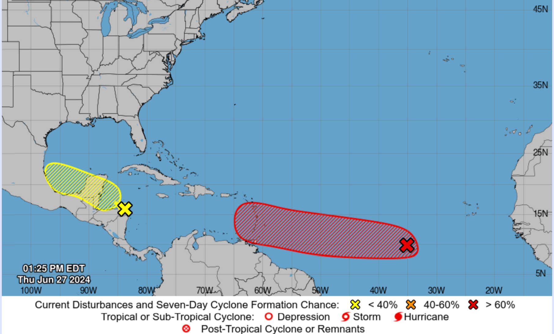
The National Hurricane Center (NHC) has announced that Tropical Wave AL95, also known as Invest 95L, is anticipated to enter the Caribbean Sea early next week. This system is expected to bring worsening marine and weather conditions to Puerto Rico and the U.S. Virgin Islands beginning late Monday and continuing into Tuesday.
Current model guidance indicates that AL95 is generating disorganized showers and thunderstorms several hundred miles west-southwest of the Cabo Verde Islands. However, environmental conditions are predicted to become favorable for development, with a tropical depression or tropical storm likely to form over the weekend. The system is moving westward at 15 to 20 mph and is expected to be several hundred miles east of the Windward Islands by the weekend.
The NHC has assessed the following probabilities for AL95’s development:
- Formation chance through 48 hours: Medium (60 percent)
- Formation chance through 7 days: High (80 percent)
The NHC advises that those in the Lesser Antilles, Puerto Rico, and the USVI should closely monitor the system’s progress. Given the dynamic and evolving nature of the situation, the next tropical weather outlook is scheduled for 8:00 p.m. AST. Residents are encouraged to stay informed and prepared as the system approaches.
Further updates and detailed briefings will be provided daily as the tropical wave advances.
Weather
Hurricane Beryl Leaves Destruction and Death; Jamaica Under Hurricane Warning; Coastal Flood Advisory for St. Croix
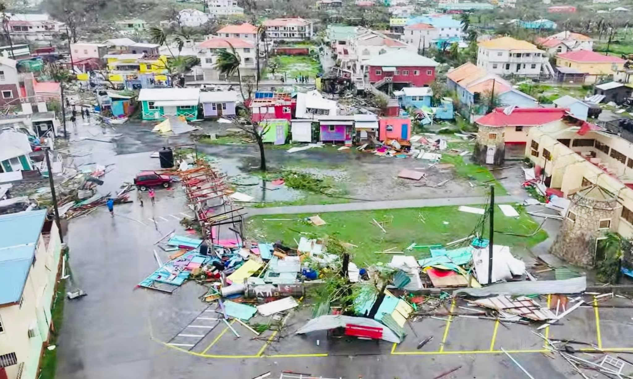
Hurricane Beryl has unleashed widespread destruction and claimed at least one life in St. Vincent and the Grenadines, according to Prime Minister Ralph Gonsalves. Union Island, part of the Grenadines, experienced significant devastation with 90 percent of homes damaged, many losing roofs or being completely destroyed. Carriacou in Grenada also suffered extensive damage, with drone footage revealing numerous homes with destroyed roofs. Although Barbados was impacted, it did not receive a direct hit from the storm.
Current Warnings
Hurricane Warning:
- Jamaica
Tropical Storm Warning:
- South coast of the Dominican Republic from Punta Palenque to the Haitian border
- South coast of Haiti from the Dominican Republic border to Anse d’Hainault
A Hurricane Warning signifies that hurricane conditions are expected within 36 hours, while a Tropical Storm Warning indicates tropical storm conditions are expected within the same timeframe.
Monitoring Beryl
Residents in the Cayman Islands and the northwestern Caribbean should closely monitor Beryl, as additional watches or warnings may be issued. Despite Beryl’s severe impact in the central Caribbean, Puerto Rico and the Virgin Islands are expected to experience increased showers and gusty winds on Tuesday, with potential strong wind gusts accompanying the rain. Following Beryl, Saharan dust is forecasted to move in on Wednesday, followed by another tropical wave on Thursday with a 30 percent chance of becoming a tropical cyclone.
Coastal Conditions
The main impact on the U.S. Virgin Islands and Puerto Rico will be deteriorating marine and coastal conditions. A Coastal Flood Advisory is in effect from 6:00 a.m. to 6:00 p.m. AST on Tuesday for St. Croix, Vieques, and the southern coast of Puerto Rico due to waves up to 17 feet. Seas are expected to reach 8 to 15 feet as the system passes to the south on Tuesday.
Hurricane Beryl’s Current Status
As of 2:00 a.m. AST, Hurricane Beryl was located near latitude 14.2 North, longitude 65.8 West, moving west-northwest at 22 mph. The NOAA Hurricane Hunters reported maximum sustained winds of 165 mph, classifying Beryl as a Category 5 hurricane. Although fluctuations in strength are likely, Beryl is expected to remain a major hurricane as it approaches Jamaica on Wednesday, with weakening expected thereafter.
Expected Impact on Jamaica and Hispaniola
Wind:
Hurricane conditions are anticipated in Jamaica by Wednesday, with tropical storm conditions expected along the south coast of Hispaniola later today.
Storm Surge:
Storm surge could raise water levels by 3 to 5 feet above normal tide levels along Jamaica’s coast and by 1 to 3 feet along Hispaniola’s southern coast.
Rainfall:
Beryl is expected to produce 4 to 8 inches of rain, with localized maxima of 12 inches in Jamaica on Wednesday, potentially causing flash flooding. Rainfall from Beryl’s outer bands may impact Hispaniola with 2 to 6 inches of rain possible.
Surf:
Large swells generated by Beryl will continue across the Windward and southern Leeward Islands over the next few days, reaching the southern coasts of Puerto Rico and Hispaniola later today. These swells are likely to cause life-threatening surf and rip current conditions.
Additional Weather Systems
An area of low pressure about 1,000 miles east-southeast of the Windward Islands is generating disorganized showers and thunderstorms. While environmental conditions are only marginally conducive for development, heavy rainfall is possible midweek in the Lesser Antilles.
- Formation chance through 48 hours: Low (20 percent)
- Formation chance through 7 days: Low (30 percent)
Weather
Major Hurricane Beryl to Impact Windward Islands Monday Morning with Life-Threatening Conditions
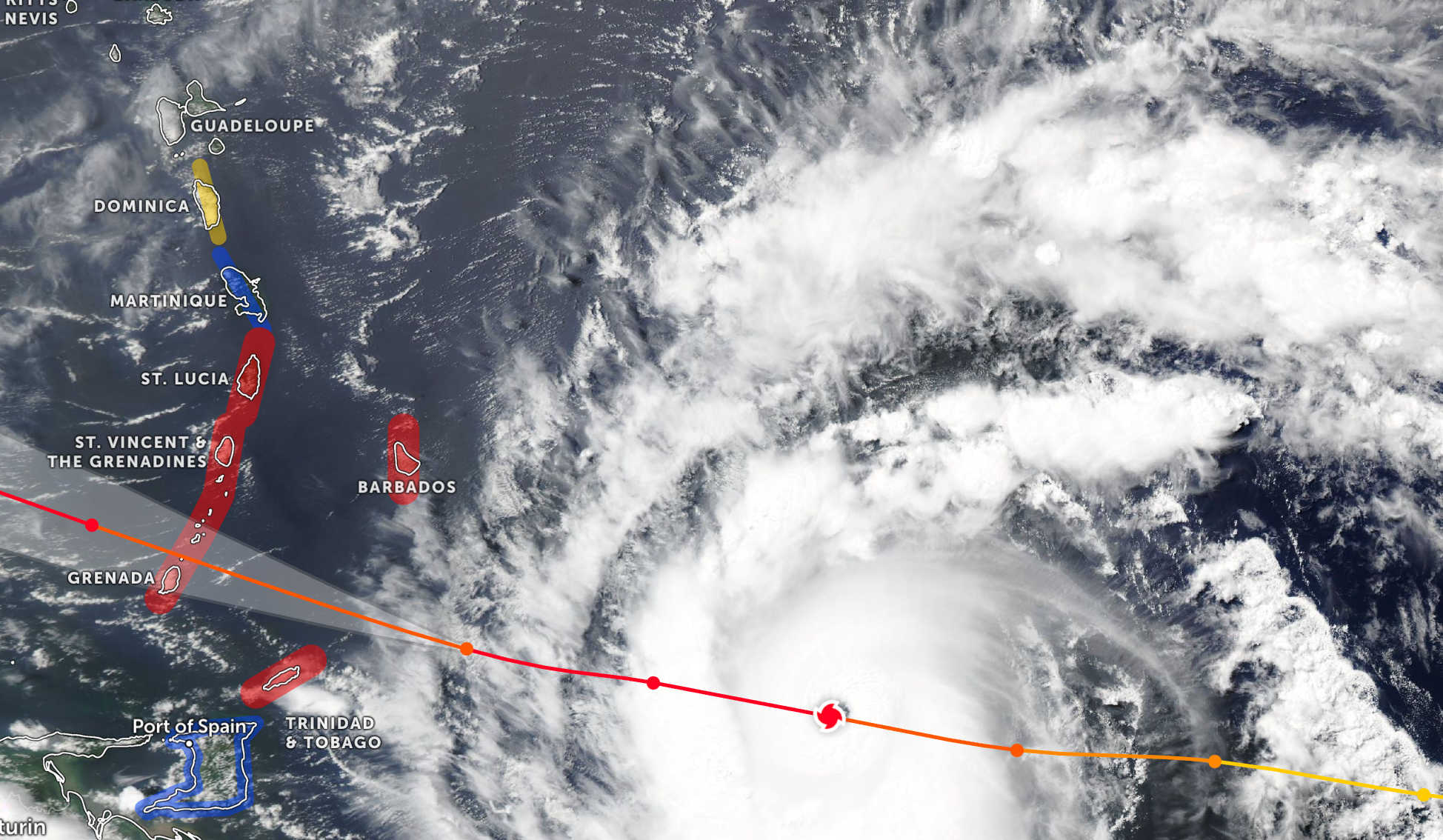
Major Hurricane Beryl is expected to reach the Windward Islands early Monday morning, bringing life-threatening winds and a significant storm surge. The National Hurricane Center (NHC) has issued a comprehensive advisory detailing the hurricane’s intensity and projected path, urging residents to take immediate precautions.
As of 5:00 a.m. AST, Hurricane Beryl was positioned near latitude 11.7 North and longitude 59.9 West, approximately 125 miles east-southeast of Grenada and 140 miles southeast of St. Vincent. The hurricane is advancing westward at 20 mph, with maximum sustained winds of 120 mph, classifying it as a Category 3 hurricane on the Saffir-Simpson Hurricane Wind Scale.
Warnings and Watches in Effect:
- Hurricane Warning: Barbados, St. Lucia, St. Vincent and the Grenadine Islands, Grenada, Tobago.
- Tropical Storm Warning: Martinique, Trinidad.
- Tropical Storm Watch: Dominica, South coast of the Dominican Republic from Punta Palenque westward to the border with Haiti, South coast of Haiti from the border with the Dominican Republic to Anse d’Hainault.
A Hurricane Warning indicates that hurricane conditions are anticipated within the warning area, typically issued 36 hours before the expected onset of tropical-storm-force winds. Residents should expedite preparations to safeguard life and property. A Tropical Storm Warning signifies that tropical storm conditions are expected within the warning area within 36 hours. A Tropical Storm Watch suggests that tropical storm conditions are possible within the watch area, generally within 48 hours.
Beryl is forecasted to cause severe wind damage, particularly in areas where its core passes, with the highest risk in St. Vincent and the Grenadines, and Grenada. Hurricane-force winds extend outward up to 35 miles from the center, while tropical-storm-force winds extend outward up to 125 miles. Devastating wind damage is expected in the warning areas starting early this morning.
A life-threatening storm surge could elevate water levels by 6 to 9 feet above normal tide levels in areas with onshore winds near Beryl’s landfall. This surge will be accompanied by large and destructive waves. Rainfall totals of 3 to 6 inches are anticipated across Barbados and the Windward Islands, with localized maxima of 10 inches possible, particularly in the Grenadines and Grenada, potentially causing flash flooding in vulnerable areas.
Marine Conditions in U.S. Virgin Islands and Puerto Rico
The U.S. Virgin Islands and Puerto Rico are preparing for worsening marine conditions starting Monday evening. The hurricane’s center is expected to pass approximately 259 miles south of St. Croix and around 230 miles south of Cabo Rojo from late Monday night through Tuesday. Despite staying well south, marine conditions will significantly worsen, with seas rising to 10-15 feet or more and winds reaching 25 knots or stronger near thunderstorms. Beryl’s outer bands may bring squally weather, with rainfall amounts between 1 and 2 inches, and localized amounts between 2 and 4 inches, causing strong gusty winds and hazardous marine conditions.
The NHC is also monitoring an area of low pressure, designated as Invest 96L, located several hundred miles southwest of the Cabo Verde Islands. This system has a 70% chance of formation over the next seven days and could approach the islands between late Wednesday night and Thursday.
Residents in the Lesser Antilles, Hispaniola, Jamaica, the Cayman Islands, and the remainder of the northwestern Caribbean should closely monitor Beryl’s progress. Additional watches or warnings may be issued today.

On June 27, 2024, the Virgin Islands Territorial Emergency Management Agency (VITEMA) issued an excessive heat warning and heat advisories for the U.S. Virgin Islands. The warning comes as temperatures are expected to soar, with heat indexes potentially reaching dangerous levels over the next few days.
Heat Advisory Details
The National Weather Service (NWS) has indicated that daytime temperatures could climb to between 100 and 105 degrees Fahrenheit, with heat index values possibly exceeding 110 degrees Fahrenheit in certain areas. The warning emphasizes the severe health risks posed by prolonged exposure to such extreme conditions.
Health Risks and Safety Measures
Excessive heat warnings are typically issued when the heat index is forecasted to reach or exceed 105 degrees Fahrenheit for at least two consecutive days. During such conditions, the likelihood of heat-related illnesses, such as heat exhaustion and heat stroke, significantly increases. The combination of high temperatures and humidity can create a dangerous environment for residents and visitors, particularly the elderly, children, and individuals with pre-existing health conditions.
To mitigate the risks associated with the extreme heat, VITEMA and the American Red Cross have provided several safety recommendations:
- Stay Informed: Monitor local weather forecasts and stay updated on heat advisories and warnings.
- Stay Hydrated: Drink plenty of water, even if you do not feel thirsty, and avoid beverages containing caffeine or alcohol.
- Limit Outdoor Activities: Avoid strenuous activities during the hottest parts of the day, typically between 10 a.m. and 4 p.m.
- Seek Air Conditioning: Spend time in air-conditioned places such as shopping malls, libraries, or community centers. If your home lacks air conditioning, consider visiting these locations during peak heat hours.
- Check on Vulnerable Individuals: Regularly check on family, friends, and neighbors who do not have air conditioning or who are more susceptible to heat-related illnesses.
Community Preparedness
The community is encouraged to review and update their emergency plans, ensuring they are equipped to handle power outages that may accompany the excessive heat. Additionally, the NWS recommends keeping an emergency kit with essential items, including water, non-perishable food, and medications.
Pet owners should ensure their animals have access to plenty of water and shade, and never leave pets or children in parked vehicles, as temperatures inside can rise rapidly to lethal levels.
With temperatures expected to remain high over the next several days, it is crucial for residents and visitors in the U.S. Virgin Islands to take the necessary precautions to stay safe. By following the guidelines provided by VITEMA and the American Red Cross, the community can minimize the health risks posed by this extreme heat event.


Krystal Eddy Earns Best Blocker Award at NORCECA Tournament

St. Croix to Host Vibrant Mango Melee and Tropical Fruit Festival on July 7

Dagou’Ville Opens as a Vibrant Hub for Food, Fun, and Music

CTE Board Enthusiastic About New Curriculum Standards, Yet Anxious Over Apprenticeship Support

Costs Surge as Donoe Estates Housing Project Resumes with New Contractor

Registered Sex Offender Detained for Illegal Firearm Possession During Annual Surveillance Drive


-
 Education11 months ago
CTE Board Enthusiastic About New Curriculum Standards, Yet Anxious Over Apprenticeship Support
-
 Development2 months ago
Costs Surge as Donoe Estates Housing Project Resumes with New Contractor
-
 Crime11 months ago
Registered Sex Offender Detained for Illegal Firearm Possession During Annual Surveillance Drive
-

 Crime9 months ago
St. John’s Westin Resort Scene of Armed Robbery, Prompting Heightened Police Vigilance
-

 Crime11 months ago
Unraveling the Home Invasion in St. John: Suspect Held on $100,000 Bail
-

 Videos2 years ago
2022 Gubernatorial Election: Voters Speak Out
-

 Crime11 months ago
U.S. Virgin Islands Alert: Megan Smith Goes Missing; Authorities Request Community Aid
-

 Videos2 years ago
Behind the Lens: Meet Kareem of Funtime Jetski & Boat Charters