Weather
Heavy Rainfall Forecast for USVI and Puerto Rico: NWS Issues Urgent Advisory
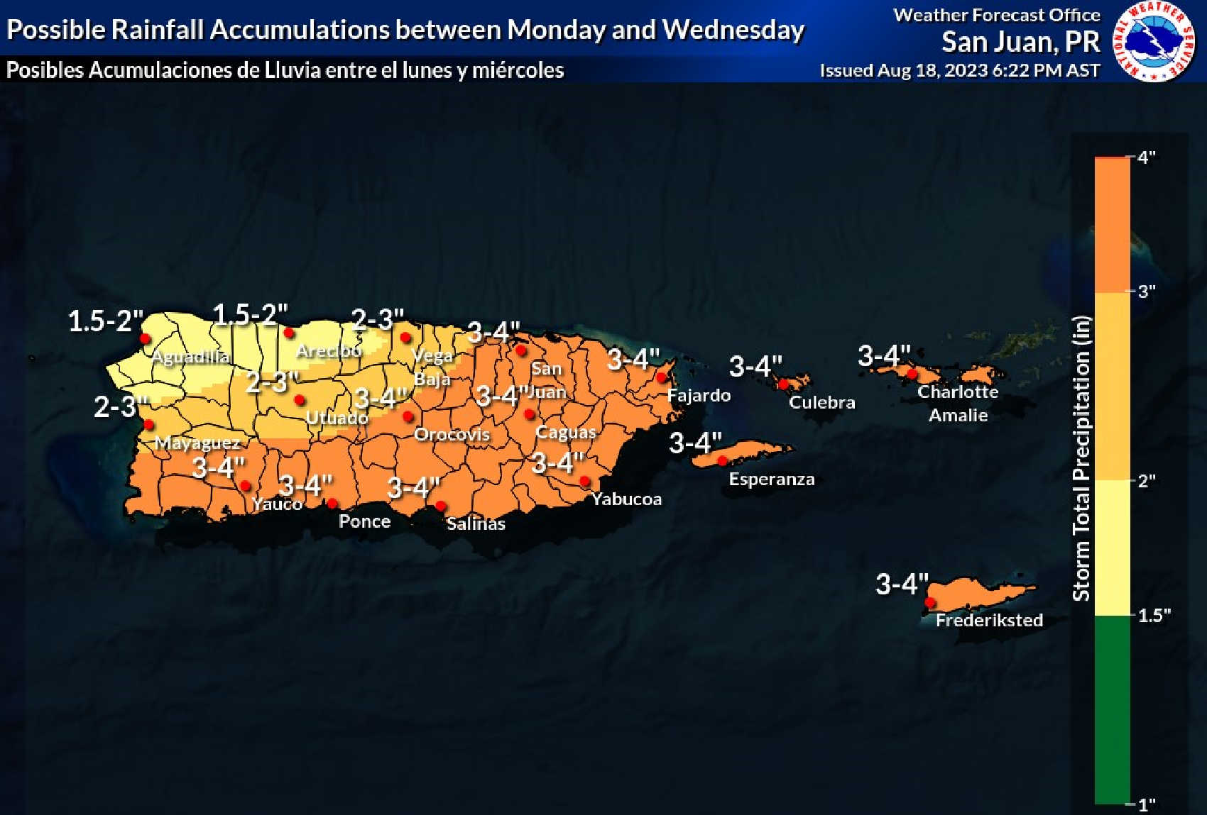
The National Weather Service (NWS) situated in Puerto Rico has sounded the alarm for potential inclement weather patterns targeting the region early next week. Both locals and visitors in the US Virgin Islands (USVI) and Puerto Rico are being alerted to brace for what appears to be an impending deluge.
According to the most recent insights from the National Hurricane Center coupled with the predictive analytics of the NWS, a series of thunderstorms accompanied by significant rainfall are on the horizon. The root cause of this imminent weather disturbance can be traced back to a powerful tropical wave, set to make its mark on the region between the start of the week and midweek.
St. Croix seems to be the prime focal point of this looming weather disturbance. Based on the projections from the NWS, the island could be drenched in approximately 3 to 4 inches of rainfall. It’s noteworthy to mention that the island’s western flank may be at the receiving end of even more aggressive rainfall. But it’s not just St. Croix; both St. Thomas and St. John are flagged for a potential downpour, hinting at a moisture-laden commencement to the week for the whole of USVI.
In its advisory, the NWS has placed an emphasis on the significance of staying informed. Their statement underscores the potential volatility of the situation, “Anticipate a period of unsettled weather with possible thunderstorms and heightened rainfall activity spanning from Monday to Wednesday. We cannot stress enough the importance of keeping an eye on regular weather bulletins throughout the weekend.”
As the clouds gather and the region readies itself for the impending showers, it’s paramount for everyone—residents and tourists alike—to stay vigilant. Regularly checking weather updates, prepping for any adverse conditions, and taking steps to safeguard personal and communal properties is the need of the hour. The key takeaway is to stay informed, stay prepared, and above all, stay safe.

The Virgin Islands, known for their pristine beaches and vibrant tourism industry, are significantly influenced by tropical weather patterns. As of July 2024, the impact of tropical winds, especially those associated with hurricanes and tropical storms, continues to shape the region’s tourism dynamics.
Current Tropical Activity
Hurricane Beryl, a major Category 4 hurricane, has recently made headlines as it moves through the Caribbean. While the center of Beryl is forecasted to pass south of the Virgin Islands, the region is expected to experience deteriorating marine conditions, including high seas and strong winds. Waves could reach up to 15 feet, and winds may gust up to 30 mph, potentially disrupting marine activities and causing hazardous conditions for tourists.
The National Hurricane Center and local weather services have issued several advisories, including High Rip Current Risks, High Surf Advisories, and Small Craft Advisories. These conditions are expected to affect the Virgin Islands through early next week, impacting water-based tourism activities such as boating, diving, and snorkeling.
Seasonal Weather Patterns
The Virgin Islands experience a tropical climate with distinct wet and dry seasons. The wet season, from May to November, coincides with the Atlantic hurricane season, bringing increased rainfall and the potential for tropical storms. This period is marked by higher humidity and more frequent rain showers, which can sometimes deter tourists seeking a sunny beach vacation.
Conversely, the dry season, from December to April, offers more stable weather conditions with lower humidity and less precipitation. This season is generally considered the peak tourist season, attracting visitors seeking to escape colder climates. However, even during this period, trade winds can influence daily weather, bringing occasional bouts of cloudiness and wind.
Impact on Tourism
Tourism in the Virgin Islands has shown resilience, even amidst challenging weather conditions. The USVI has reported a significant increase in air arrivals, with a 26% rise compared to the same period in 2023. This growth is a testament to the region’s appeal and the effectiveness of its tourism marketing strategies.
However, tropical winds and storms can disrupt travel plans and affect tourist activities. Hotels and resorts often implement hurricane preparedness plans to ensure the safety of guests during severe weather events. Additionally, tourists are advised to stay informed about weather conditions and adjust their plans accordingly, such as opting for indoor activities or exploring safer areas away from the coastline during storm warnings.
Mitigation Strategies
Tourism stakeholders in the Virgin Islands are proactive in mitigating the impacts of tropical weather. They provide real-time weather updates and advisories, encourage visitors to purchase travel insurance, and offer flexible booking options during the hurricane season. Resorts and hotels are designed to withstand tropical storms, and staff are trained to manage emergency situations effectively.
In conclusion, while tropical winds and storms pose challenges to tourism in the Virgin Islands, the region remains a popular destination due to its natural beauty and well-coordinated tourism management strategies. Travelers are encouraged to plan their visits with weather considerations in mind, ensuring a safe and enjoyable experience in this tropical paradise.

Basking in the radiant sunshine of the U.S. Virgin Islands is an experience like no other. With its crystal-clear waters, pristine beaches, and rich cultural heritage, the USVI offers countless ways to enjoy its sunny days. Here’s a guide to making the most of your time in this tropical paradise.
St. Thomas: A Blend of Adventure and Relaxation
Begin your sunny adventure in St. Thomas, an island known for its vibrant culture and stunning beaches. Start your day at Magens Bay, one of the Caribbean’s most beautiful beaches. Here, you can soak up the sun on the soft white sands or take a refreshing dip in the turquoise waters. For a more interactive experience, visit Coral World Ocean Park. This marine park offers close encounters with sea creatures, including dolphins and turtles, making it a perfect spot for families.
If you’re looking for a bit of history, climb the 99 Steps in Charlotte Amalie. These steps, built by the Danish in the 18th century, lead to breathtaking views of the island. For a taste of local life, explore the shops and restaurants in Red Hook. This bustling town offers a variety of dining options and vibrant nightlife, providing a perfect end to a sunny day.
St. John: Nature’s Sanctuary
For those seeking a more tranquil and nature-focused experience, St. John is the ideal destination. With two-thirds of the island designated as Virgin Islands National Park, St. John offers untouched beauty and serene landscapes. Hike the trails of Cinnamon Bay and explore the historical ruins of old sugar plantations along the way.
Trunk Bay, famous for its underwater snorkeling trail, is a must-visit. Here, you can snorkel through vibrant coral reefs and witness a variety of marine life. The tranquility of Coral Bay, on the island’s southeastern side, is perfect for those looking to escape the crowds and enjoy a peaceful beach day.
St. Croix: Cultural Richness and Natural Beauty
St. Croix combines historical charm with natural beauty, making it a unique destination in the USVI. Start your exploration in Christiansted, where you can visit Fort Christiansvaern and learn about the island’s colonial history. For an unforgettable snorkeling experience, take a trip to Buck Island Reef National Monument. This protected area offers stunning coral reefs and diverse marine life, perfect for a morning or afternoon adventure.
St. Croix is also known for its culinary delights. Enjoy local dishes at roadside eateries or indulge in fine dining at one of the many upscale restaurants in Christiansted. Don’t miss a visit to the island’s rum distilleries, such as Cruzan Rum and Captain Morgan, where you can tour the facilities and sample the local spirits.
Practical Tips for Enjoying the Sunshine
The USVI enjoys a tropical climate, ensuring warm, sunny weather year-round. Average temperatures range from 73°F to 88°F, with the warmest months from June to October. While the islands are generally sunny, be prepared for occasional rain showers, especially during the rainy season from May to November.
Renting a car is highly recommended to explore the islands fully, as public transportation is limited. Remember, driving is on the left side of the road. It’s also wise to carry cash, as some smaller establishments may not accept credit cards. Always stay hydrated and use sunscreen to protect yourself from the strong Caribbean sun.
By following this guide, you can make the most of your sunny days in the U.S. Virgin Islands, creating unforgettable memories in this tropical paradise.

As the Atlantic hurricane season approaches, residents of the U.S. Virgin Islands (USVI) must take proactive steps to safeguard their homes and families. The season runs from June 1 to November 30, with peak activity between mid-August and late October. Here are some essential tips and recommendations to ensure you’re fully prepared.
Understand Your Risks and Plan Accordingly
Know Your Evacuation Zone Identify whether you live in a hurricane evacuation area by contacting local emergency management offices or checking relevant evacuation websites. Familiarize yourself with local evacuation routes and have a plan for where you can stay if ordered to evacuate. Ensure your family is aware of the plan and routes.
Create an Emergency Kit An emergency supply kit is crucial. It should include essentials such as water, non-perishable food, a flashlight, batteries, cash, first aid supplies, medications, and copies of critical information. For those with pets, prepare a pet emergency kit with food, water, and any necessary medications.
Prepare Your Home
Secure Your Property Before the hurricane season, inspect and reinforce your home to withstand high winds. Trim or remove damaged trees and limbs, secure loose rain gutters and downspouts, and clear clogged areas to prevent water damage. Consider retrofitting to secure and reinforce the roof, windows, doors, and garage doors.
Install Storm Shutters Storm shutters provide additional protection for windows and glass doors. If storm shutters are not available, use plywood panels to cover windows.
Generators and Power Supplies Invest in a portable generator to maintain power during outages. Ensure it is placed outside, at least 20 feet away from windows and doors, and protected from moisture. Never attempt to power the house by plugging a generator into a wall outlet.
Stay Informed and Communicate
Sign Up for Alerts Register for local emergency alerts and notifications via text message, email, or other methods. Websites like Alert VI provide critical updates during emergencies.
Emergency Communication Plan Discuss and document a family emergency communication plan. This plan should include how you will contact each other, where you will meet, and what to do in various scenarios. Make sure all family members, including children, understand the plan.
Monitor Weather Updates Stay updated with the latest weather forecasts and alerts from reliable sources like the National Weather Service (NWS). Understanding the difference between a hurricane watch (conditions possible within 48 hours) and a warning (conditions expected within 36 hours) can help you take timely actions.
Insurance and Documentation
Review Insurance Policies Check your insurance coverage to ensure it is adequate for hurricane-related damages. This includes flood insurance, as standard homeowners’ policies typically do not cover flood damage. Keep digital copies of important documents and photographs of your property’s condition before the storm.
Financial Preparedness Prepare for the possibility of power outages affecting ATMs and credit card machines. Keep extra cash on hand as part of your emergency kit.
Additional Resources
For more detailed information on hurricane preparedness, you can visit Ready.gov, FEMA, and the Virgin Islands Territorial Emergency Management Agency (VITEMA).
By taking these steps, you can significantly reduce the risks and impacts of hurricanes on you and your family. Preparing well in advance ensures that you can respond effectively and stay safe during hurricane season.


Blue Skies Sandbag Distribution Scheduled for Seniors and Homebound Physically-Challenged Residents

Innovations in Agriculture in the U.S. Virgin Islands

Street Food in the Virgin Islands: What to Try

CTE Board Enthusiastic About New Curriculum Standards, Yet Anxious Over Apprenticeship Support

Registered Sex Offender Detained for Illegal Firearm Possession During Annual Surveillance Drive

Costs Surge as Donoe Estates Housing Project Resumes with New Contractor

-
 Education11 months ago
CTE Board Enthusiastic About New Curriculum Standards, Yet Anxious Over Apprenticeship Support
-
 Crime11 months ago
Registered Sex Offender Detained for Illegal Firearm Possession During Annual Surveillance Drive
-
 Development3 months ago
Costs Surge as Donoe Estates Housing Project Resumes with New Contractor
-

 Crime9 months ago
St. John’s Westin Resort Scene of Armed Robbery, Prompting Heightened Police Vigilance
-

 Videos2 years ago
2022 Gubernatorial Election: Voters Speak Out
-

 Crime11 months ago
Unraveling the Home Invasion in St. John: Suspect Held on $100,000 Bail
-

 Videos2 years ago
Gubernatorial Teams Celebrate St. Croix’s Bull & Bread Day
-

 Videos2 years ago
Behind the Lens: Meet Kareem of Funtime Jetski & Boat Charters