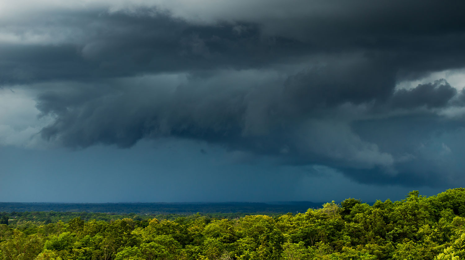
Hurricane Season
USVI and Leeward Islands Brace for Dangerous Surf as Cat 5 Hurricane Lee Tracks North
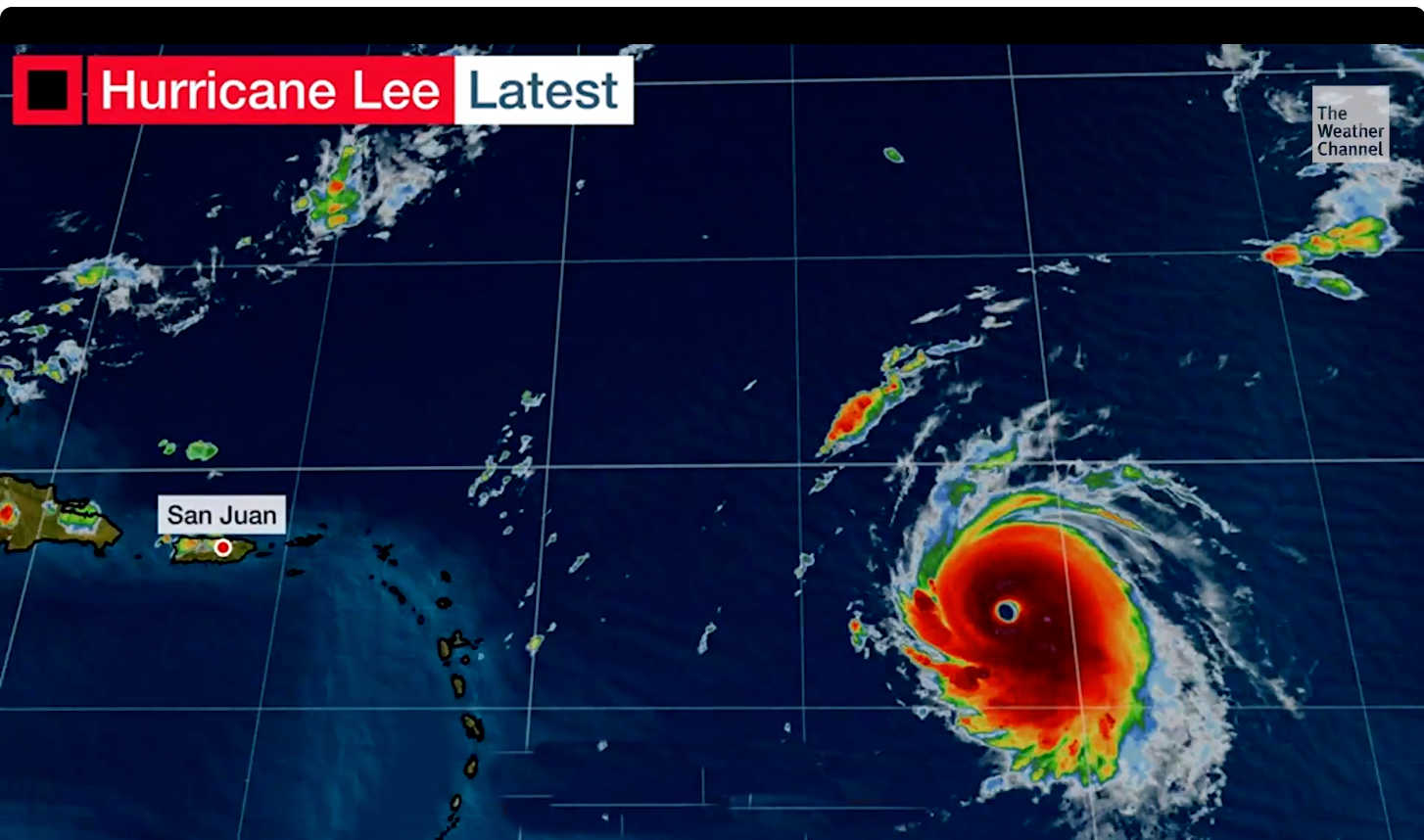
In the midst of the Atlantic, the fierce Category 5 Hurricane Lee is generating winds of almost 165 mph, prompting urgent advisories regarding life-endangering surf and rip currents expected to hit the northern Leeward Islands by this evening.
The menace of these hazardous conditions is forecasted to reach the U.S. Virgin Islands, and subsequently spread to regions including Puerto Rico, Hispaniola, the Turks and Caicos, the Bahamas, and even as far as Bermuda during the weekend. The East Coast of the U.S. is also on high alert for potential treacherous surf conditions by Sunday.
Although predictions indicate that Hurricane Lee’s core will bypass the Leeward Islands from a distance to the north, the surge it produces cannot be underestimated. Forecasts suggest sea levels could escalate by 8 to 12 feet, especially in the Atlantic side and eastern pockets of these islands. As the hurricane intensifies and edges closer to the northeastern Caribbean region, even more formidable sea surges are on the horizon. The byproducts of these swells, which include dangerous rip currents and towering surf, are predicted to predominantly affect the northern and eastern coastlines of Puerto Rico and the U.S. Virgin Islands. The situation could also escalate to coastal flooding and increased erosion from Sunday evening into the early hours of Monday.
There is still some ambiguity regarding potential rainfall and any associated wind damage. But there’s consensus in predictions that Lee will predominantly venture north-northeast, away from the island territories. Island residents are strongly advised to stay abreast with the latest updates on this evolving situation.
Recent insights from the Air Force Reserve’s Hurricane Hunter aircraft unveiled that Lee has achieved a category 5 rating on the Saffir-Simpson Hurricane Wind Scale, with prospects of further intensification in the coming hours. The hurricane’s current coordinates place it near latitude 17.8 North and longitude 53.5 West, as it journeys west-northwest at a pace of roughly 14 mph. This path is predicted to maintain its course into the forthcoming week, though with a notable reduction in its speed.
In terms of wind outreach, Hurricane Lee’s potent force extends about 45 miles from its nucleus, while its tropical storm winds have a radius of around 140 miles. The recorded minimum central atmospheric pressure stands at 926 mb (27.35 inches).
As for its potential threat to the U.S. East Coast, Atlantic Canada, or Bermuda in the upcoming week, authorities maintain that it’s premature for conclusive forecasts. The hurricane’s anticipated deceleration over the southwestern Atlantic complicates predictions. Nonetheless, coastal residents and administrative bodies on the U.S. East Coast are encouraged to remain vigilant and frequently check updates concerning Hurricane Lee’s progress.
As storm season approaches, residents of the U.S. Virgin Islands must prepare to protect their homes, families, and communities from the potential threats posed by hurricanes and tropical storms. Proper preparation not only ensures safety but also minimizes the impact of severe weather events. Below are essential guidelines for USVI residents to stay ready during the storm season.
1. Stay Informed with Reliable Sources
One of the most crucial aspects of storm preparation is staying informed. Keep up with weather updates from reliable sources such as the National Hurricane Center (NHC) and the Virgin Islands Territorial Emergency Management Agency (VITEMA). Sign up for alerts and warnings through local news outlets and emergency notification systems to receive real-time updates.
2. Create an Emergency Plan
Every household should have a comprehensive emergency plan in place. Discuss with family members what to do before, during, and after a storm. Identify a safe room within your home, typically an interior room with no windows, where you can take shelter. Designate an out-of-town contact person who can coordinate communication in case local networks are down.
3. Build an Emergency Kit
An emergency kit is vital for surviving the aftermath of a storm. Ensure your kit includes:
- Non-perishable food and water: A three-day supply for each family member.
- First aid supplies: Bandages, antiseptics, medications, and other essentials.
- Important documents: Copies of identification, insurance policies, and medical records.
- Tools and supplies: Flashlights, batteries, a multi-tool, and duct tape.
- Hygiene products: Hand sanitizer, soap, and personal hygiene items.
- Communication tools: A battery-powered radio, mobile phone chargers, and a whistle for signaling.
4. Secure Your Home
Taking steps to secure your home is essential to minimize damage during a storm. Inspect your property for potential hazards, such as loose branches, and trim trees that could cause damage if they fall. Reinforce windows and doors with storm shutters or plywood to protect against strong winds and flying debris. Additionally, consider securing outdoor furniture, grills, and other items that could become projectiles during a storm.
5. Review Your Insurance Coverage
Before the storm season begins, review your homeowner’s insurance policy to ensure it covers hurricane-related damage. Note that standard insurance policies often do not cover flooding, so you may need to purchase separate flood insurance. Keep your insurance documents in a safe, easily accessible place, and take inventory of your belongings to streamline the claims process if necessary.
6. Plan for Special Needs
If there are elderly family members, individuals with disabilities, or pets in your household, make specific arrangements for their care during a storm. Ensure you have enough medication, special dietary items, and pet supplies on hand. Identify nearby shelters that can accommodate these needs and plan for transportation if evacuation becomes necessary.
7. Know Evacuation Routes
Familiarize yourself with the designated evacuation routes in your area. VITEMA provides maps and guidelines on evacuation procedures that can be accessed online. Plan your route in advance, and keep a full tank of gas in your vehicle during storm season to ensure you can evacuate quickly if needed. Always follow local authorities’ instructions regarding evacuations.
8. Prepare for Power Outages
Storms often lead to power outages, which can last for days or even weeks. Prepare by having a backup power source, such as a generator, and stock up on batteries for flashlights and other essential devices. Charge your electronic devices ahead of time, and consider investing in a solar-powered charger. Perishable food should be consumed first, and frozen items can be kept cold longer by packing them tightly together in the freezer.
9. Stay Connected with Your Community
Community support is invaluable during storm season. Engage with your neighbors to create a support network. Share resources and information, especially with those who may need extra assistance. Participate in community meetings and workshops on disaster preparedness offered by local organizations.
10. Post-Storm Safety
After a storm passes, it’s important to stay vigilant. Avoid downed power lines and flooded areas, and report any damage to local authorities. Check on neighbors and offer assistance where needed. Listen to official announcements regarding when it is safe to return home if you have evacuated.
Preparation is the key to safety during storm season in the U.S. Virgin Islands. By staying informed, having an emergency plan, and taking proactive measures to protect your home and family, you can minimize the impact of storms and ensure a quicker recovery. Make storm preparedness a priority today, and encourage others in your community to do the same.
With these steps, USVI residents can navigate storm season with confidence, knowing they have done everything possible to protect themselves and their loved ones.
Hurricane Season
FEMA Urges Virgin Islands Residents to Update Emergency Plans as Hurricane Season Begins
As the Atlantic hurricane season commences, the Federal Emergency Management Agency (FEMA) is urging U.S. Virgin Islands residents to brace for what is expected to be an above-normal season. The National Oceanic and Atmospheric Administration (NOAA) has predicted between 17 and 25 named storms for 2024, underscoring the importance of readiness in the region.
FEMA is stressing the necessity of updating emergency communication plans to enhance safety and reduce the stress associated with approaching tropical systems. It is crucial for residents to revisit and revise their plans, ensuring all family members are well-versed in the procedures to follow if a storm threatens the area.
FEMA’s key recommendations include:
- Plan Review and Update: Families should reassess their emergency plans, taking into account any changes over the past year. It’s essential that every member understands their role and the actions to take during an emergency.
- Communication Strategy: Designate a family member outside the territory as an emergency contact. This person can serve as a central point of communication for relatives and friends if local channels are disrupted.
- Accessible Information: FEMA provides an emergency communications plan template to document vital contact and medical information for each family member. This template is also available in Spanish, making it more accessible to a broader audience.
In addition to updating plans, FEMA advises residents to conduct practice drills. These drills help ensure that everyone knows how to communicate effectively and reunite if separated during a storm.
For more details and to access the emergency communications plan template, residents can visit FEMA’s website or contact the local emergency management office. Being prepared can significantly reduce the risks and anxiety associated with hurricane season in the Caribbean.
Hurricane Season
Emergency Shelters Identified and Shelf-Stable Foods Procured as USVI Prepares for the Hurricane Season
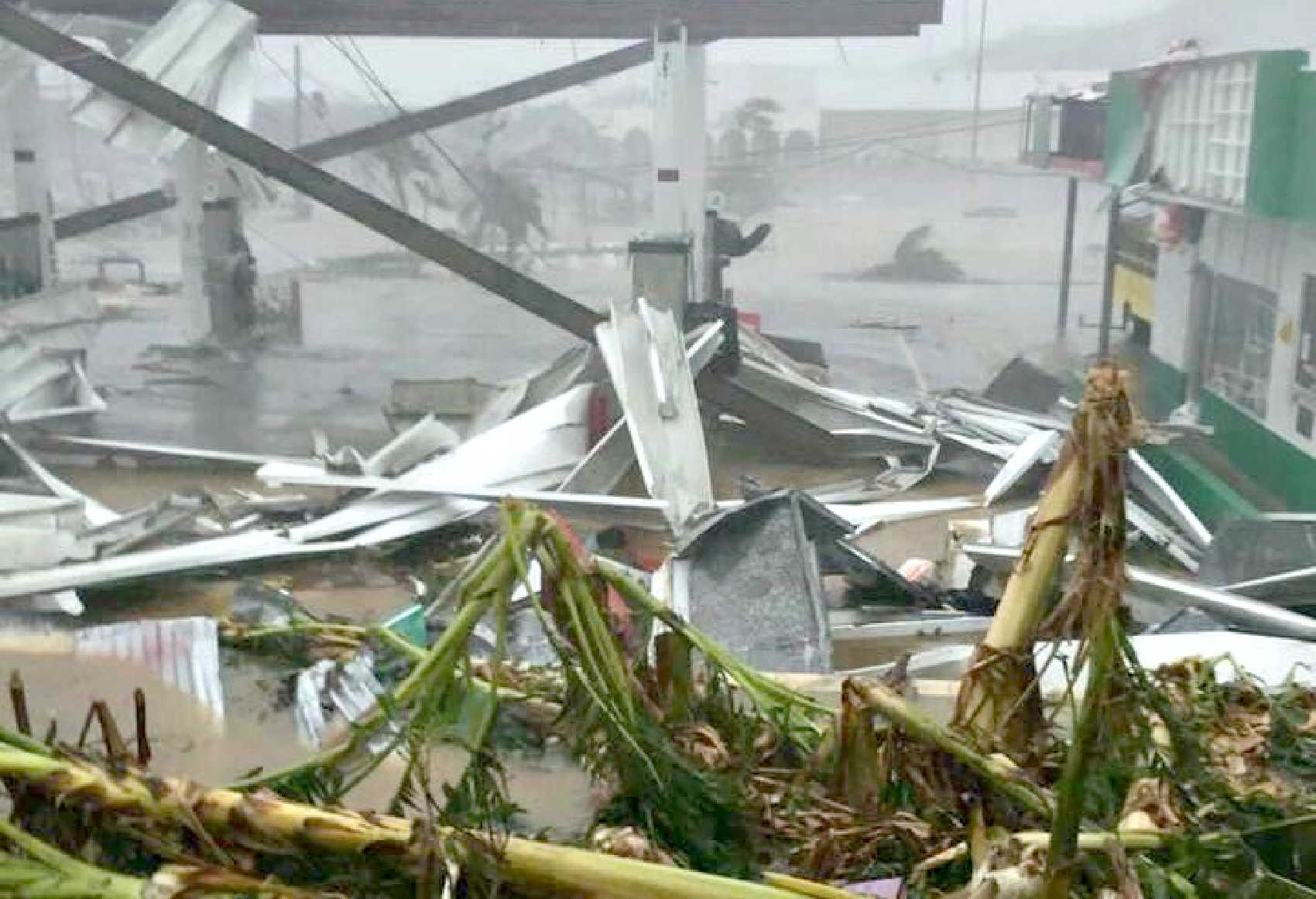
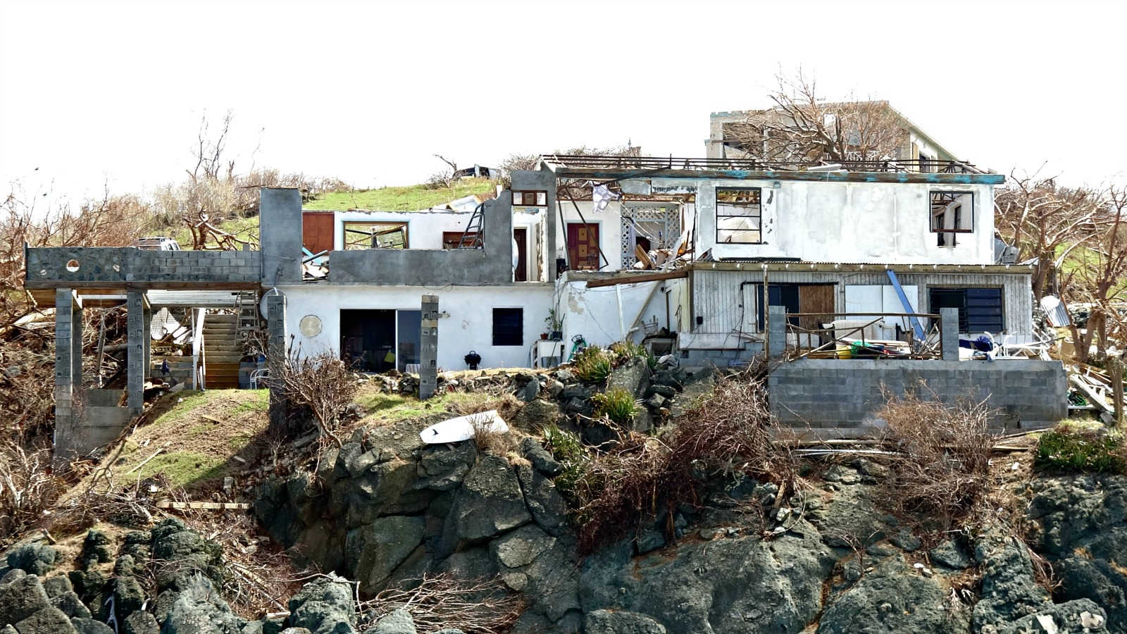
As the Virgin Islands government advances billion-dollar hurricane recovery projects initiated in 2017, residents brace for an above-normal 2024 Atlantic hurricane season, with forecasts predicting four to seven major hurricanes. Senator Kenneth Gittens convened a meeting on Wednesday with the Committee on Homeland Security, Justice, and Public Affairs to review preparedness plans. Daryl Jaschen, director of the V.I. Territorial Emergency Management Agency (VITEMA), emphasized the importance of proactive planning.
Reflecting on the 2017 hurricanes, Jaschen lamented past complacency among residents and urged serious preparation for the upcoming season. He highlighted the necessity of considering senior citizens, ensuring medication availability, and caring for pets. “We don’t want it, but we want to be prepared,” he stated.
A significant improvement in this year’s preparations is the prepositioning of FEMA-supplied shelf-stable water and meals, sufficient for ten days, within the territory. Unlike in 2017, when supplies were stored in Puerto Rico, these resources are now readily available. If necessary, food supplies will be distributed from various points of distribution (PODs) five days after a federal disaster declaration. Residents are advised to maintain a personal emergency stash for at least five days, as immediate distribution may not be possible.
VITEMA plans to operate two PODs per district, each capable of distributing up to 5,000 meals daily. These PODs will function until normal food supply chains are restored and ATMs are operational. Distribution sites will provide two meals and three liters of water per person per day.
The five-day lead time for distribution stems from the logistics of receiving and processing FEMA supplies. Jaschen warned residents not to expect immediate assistance post-storm, as it takes time to activate PODs. Road clearance is also a prerequisite for POD operations.
The exact locations for the PODs remain undecided, causing concern among legislators. Senator Gittens emphasized the need for pre-identified locations to facilitate easier access during emergencies. Jaschen responded that the final POD sites would be determined based on post-storm assessments.
The V.I. Department of Human Services (DHS) is also preparing for potential hurricane impacts. Community Affairs Coordinator Yvette Henry reported that DHS, with FEMA, the American Red Cross, and local partners, has inspected and identified several evacuation shelters. In St. Croix, the St. Croix Educational Complex and the David C. Canageta Recreational Complex are designated shelters. St. Thomas shelters include the Ivanna Eudora Kean High School’s gym and cafeteria and the Lockhart Elementary and Junior High School. St. John shelters are the Adrian Senior Center and the Gift Hill School. There is no listed shelter for Water Island for 2024.
DHS, along with the V.I. Department of Health, is ensuring shelters can meet the needs of vulnerable populations, including accommodations for service animals. DHS continues to identify additional shelters, with lawmakers urging the selection of easily accessible locations for all residents.
The V.I. Department of Public Works (DPW) is focused on stormwater management, tree pruning, sandbag distribution, route clearance, and infrastructure restoration. Assistant Labor Commissioner Rueben Jennings noted DPW’s readiness to assist in supply distribution if required. Lawmakers stressed the importance of drain maintenance to prevent flooding and debris blockage. DPW has begun assessing the stormwater drainage system and will continue these efforts throughout the hurricane season.


The Intersection of Technology and Art in the U.S. Virgin Islands

USVI Festive Drinks and Cocktails: A Taste of the Islands

Travel Essentials for Your USVI Vacation

Education Board Seeks Input on Schools Through Comprehensive Survey

CTE Board Enthusiastic About New Curriculum Standards, Yet Anxious Over Apprenticeship Support

Registered Sex Offender Detained for Illegal Firearm Possession During Annual Surveillance Drive
-
 Education1 year ago
Education Board Seeks Input on Schools Through Comprehensive Survey
-
 Education2 years ago
CTE Board Enthusiastic About New Curriculum Standards, Yet Anxious Over Apprenticeship Support
-
 Crime2 years ago
Registered Sex Offender Detained for Illegal Firearm Possession During Annual Surveillance Drive
-

 Development1 year ago
Costs Surge as Donoe Estates Housing Project Resumes with New Contractor
-
 Videos3 years ago
2022 Gubernatorial Election: Voters Speak Out
-

 Videos3 years ago
Gubernatorial Teams Celebrate St. Croix’s Bull & Bread Day
-

 Videos3 years ago
Wakanda’s Female Might: A Dive into ‘Black Panther: Wakanda Forever’
-

 Crime2 years ago
St. John’s Westin Resort Scene of Armed Robbery, Prompting Heightened Police Vigilance